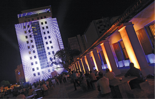
Dutch Hospital Building in Colombo
By Archt. Chiranji Abeywickrema
Post-war development activities are generating a lot of interest around the island as barricades are lifted and cities are made accessible and aesthetically appealing…
Urban Development Authority (UDA), the Ministry of Defence, Planners and Architects are contributing towards making the cities more permeable whilst uplifting urban space and improving quality of life.
Colombo was an extremely restricted zone during the period of war. Its heritage was buried in the fortifications and passage was limited. The plan for post-war regeneration encapsulates a public-oriented development programme that has been able to successfully trigger a boom in urban development and the construction industry.
State sector buildings are once again open to the public as the boundary walls are removed and open areas are declared. The streets are being cleared of physical barriers as well as unsightly litter, which have received a favourable response from the public, enhancing the levels of interaction. Pedestrian movement is facilitated by shaded walkways, paved access and facilities for the differently-abled. Water transport is also encouraged with the canal improvement schemes that enhance the beauty of the commercial capital.
Development activities connected with public spaces such as the Galle Face Green, Independence Square, Vihara Maha Devi Park, Race Course, Clock Tower in Fort are anticipated in the near future for improving public participation and uplifting the tourism industry. The grandstand and mini-stand of the race course are earmarked for renovation while meticulous effort is taken to produce measured drawings of these historic buildings. These are then developed into construction drawings that are used to alter these buildings to adaptive reuse that generate revenue whilst conserving the historic fabric. New ventures such as motor racing are introduced to the sports activities of the capital in an effort to improve its recreational potential.
The Dutch Hospital shopping precinct is one such example.
The Ministry of Defence and the UDA initiated the current development of the building which dates back to the early Dutch era. The rear of the hospital was cleared up to create a public plaza, which strengthened the presence of this ancient hospital demarcating its new entrance from Bank of Ceylon Mawatha. The plaza is geared for festivity, generating revenue through rent. The old building was restored to its ancient glory with attention to details, inclusive of importing Palmyra palm (Borassus flabellifer) rafters from Mannar to replace the damaged rafters of the roof. Furthermore, guidelines were formulated to preserve this heritage site in its original form. A sense of place was created in an upmarket neighbourhood of shops and restaurants.
Canal Row in Fort, which was used to transport patients to the hospital from the ships in the harbour was filled during the British period. The buildings bordering Canal Row and Hospital Street at present were given a facelift, encouraging the property owners to upgrade their properties under the guidance of the Urban Development Authority. The facade renovations were monitored with guidelines pertaining to signage, use of colour, etc. The buildings were restored to their original form revealing the colonial architectural elements that were suppressed due to negligence and misuse. The former fertilizer corporation and marketing department is also being renovated as part of the programme to reuse the underutilised buildings in the Fort and its surrounds. The Cargills building was upgraded by private stakeholders in a chain reaction to the development process that has seized Fort in recent times.
Semi-public sector involvement in the regeneration process is evident in the refurbishment of R Premadasa Stadium, Maligawatta – an international cricket venue. The refurbishment, which was carried out in eleven months, increased its capacity to nearly 30,000 with a four-storeyed grandstand, expansion of spectator pavilions and two new sight screen buildings of five storeys. The spectator facilities include 23 air-conditioned corporate facilities with a capacity for 20 spectators each. Players’ areas were expanded with improved dining and recreational facilities. A new scoreboard and flood lights were added to facilitate day/night cricket. The project was designed and built by the State Engineering Corporation of Sri Lanka.
The Southern Expressway was initiated in 2006 to reduce travel time between the commercial capital of Colombo and the southern parts of the island. Providing an incentive for business and tourism promotion, it connects the capital with the heritage city of Galle with a reduced travel time of one hour. The project is expected to extend up to the Magampura industrial port and regional centre in the future. 30km to Matara is expected to be completed by 2013. The highway to Galle consists of four lanes with a 1.7m lane to pull over in case of emergency. A maximum speed of 100km/h is permitted whilst billboards are prohibited as a distraction for the drivers. The new Southern Expressway has increased the potential of Galle as a travel destination and the city centre has experienced transformation in recent times with street widening programmes and other infrastructure facilities.
The central bus stand was a long anticipated project since the main bus stand was destroyed by the Tsunami in 2004 and the new bus terminal was initiated in 2007. The site was restricted, located in the heart of Galle city with traffic congestion and space limitations to cater for thousands of commuters that pass through on a daily basis. The resultant 168m long, 10m wide structure was a clever planning intervention that has successfully dealt with these challenges. The three metre cantilever of the upper storey provides adequate protection whilst preserving the openness of the ground floor.
The open structure creates visual and physical connectivity with Gamini Mawatha and the shopping district behind. The entire ground level of the terminal becomes part and parcel of the public space of the city. An overhead bridge connects the bus terminal with the railway station without disturbing the traffic flow. Increased permeability is an admirable feature of the transport terminal. The upper level is connected vertically with the ground level at three points with a single loaded corridor at the first floor giving access to shops and a view towards the rampart on one side. Adequate toilet facilities, rest rooms and disable facilities are provided in the building. Two terraces are created at the topmost level, which breaks the long span of the structure. These are to be used for communal activity-generating revenue through rent whilst providing a safety ground during a tsunami. A much needed platform for public interaction is created by the central bus stand in Galle, which was previously lacking in the city.
The township of Hambantota is currently being developed as a regional project with the new port providing ‘a gateway’ to Asia. The development plan for greater Hambantota urban development area 2010-30 based on the National Physical Plan, envisages the integration of ‘Green and Blue’ areas; ‘green’ consisting of forest, scrub and cultivations and ‘blue’ areas that include sea, reservoirs and salt pans. Bounded by Udawalawa, Thanamalwila, Walawe river and Kirindi oya, Hamabantota has the potential to be developed as a socio-cultural promotional centre with a significant historical background.
The main economic generators in Hambantota are the industrial port and the proposed airport at Mattala. The Mattala airport project was initiated to compensate for the lack of an ‘in-state’ alternative landing strip for international carriers coming to Bandaranaike International Airport (BIA) and to reduce the additional fuel load carried by these aircrafts which hinders their capacity to generate revenue through goods transportation.
Sooriyawewa Cricket Stadium, proposed botanical gardens, an oil refinery, the Southern Expressway and the proposed railroad to Kataragama are anticipated to strengthen the development of the new township of Hambantota.
The new town centre is located on 70 acres, approximately 3km inland as a Tsunami mitigation measure. The early administrative buildings are relocated to the new central business district of Siribopura and 42 government offices and semi-government institutions are located under one roof at the new administrative centre. The master plan provides for future expansion also integrating ‘green and blue areas’ for a sustainable environment in accordance with the overall vision for the regional centre of Hambantota. The design of the administrative centre has incorporated reservoirs, reflective pools in front of the complex and a tank. Natural terrain was used for the drainage system preserving the natural vegetation. The building reflects architecture of the tropics and features an array of courtyards for public interaction. Disable access was prioritised with an advanced pathfinding system to be installed in the future to guide the general public. The project was constructed in three years under the supervision of the Urban Development Authority.
A fully-fledged township consisting of a diplomatic cove, civic buildings, banks, shops, schools, residential and recreational zones are anticipated in the new central business district of Hambantota. Two ring roads provide efficient traffic movement with connectivity to Matara and Kataragama roads.
An international convention centre with state-of-the-art convention facilities, a public library, municipal council offices and depots for infrastructure agencies are also located in the administration hub. The convention centre offers conference and exhibition facilities that support the investment promotional activities generated through the seaport and the airport. An auditorium with a seating capacity of 1,500, three committee rooms with 250 seats each that can be combined into one large room, six general committee rooms, exhibition area, restaurants, a VIP lounge, an open air theatre with a capacity of 50,000 and two helipads are housed in 27 acres of land. Parking facilities are provided for approximately 840 vehicles including buses. The building is unique in form and creates a landmark of sophistication. The buildings vacated by the former administrative offices in Tower Hill are to be restored and introduced with compatible re-use with a vision to create ‘a living museum.’ Tower Hill development project in the old coastal town of Hambantota envisages re-use of ancient monuments in an integrated shopping and tourism promotional zone, opening out new vistas towards the bay.
A beach park was constructed in close proximity to the Tower Hill project offering a variety of recreational activities such as beach volleyball, football, basketball, kabaddi, restaurant facilities, etc. A managed elephant range (MER) is also part of the master plan that preserves the natural heritage of Hambantota. It includes an elephant reserve and elephant corridors for unhindered passage of the wild animals.
Proper management of available water sources is another important aspect in the arid zone of Hambantota. Harvested rain water is channelled through a system of drainage for watering large areas including the proposed golf course. Wind power generation is also encouraged with a pilot wind power plant of 3MW in operation.
Incidentally, regeneration was the theme of discussion at the national conference of the Sri Lanka Institute of Architects 2012. It was concluded that urban regeneration should respect history and tradition, promote cultural values and contribute to economic growth.
It should aim at preserving natural resources and minimising the impact on the environment throughout the project’s lifecycle. The reform that takes place through urban regeneration should uplift the quality of life, giving birth to sustainable communities.
Regeneration was also the theme of discussion at the national conference of the Sri Lanka Institute of Architects 2012. The keynote speaker at the conference Prof. Jan Gehl highlighted the need of responding to human scale starting at macro level of urban planning. Prof. Gehl addressed the lack of people orientated spaces in city planning. Frequent occurrence of public space, attention to detailing and level of human interaction enriched the way of life prior to the invasion of the motor car in 1960’s. Public space was enjoyed and readily accessed by all age groups. Prominence was given to details, which were appreciated by a person travelling at a speed of 5km/h, as a result the streetscapes displayed distinguished characteristics. Current cities are focusing on the transit population and motor traffic at a speed of 60km/h. The spatial volumes experienced are much larger in relation to human scale and little or no thought is given to the finer details. Faceless street façades are used merely for advertising while interactions with the streets are obscured.
Dr. L.S.R. Perera voiced concern in degeneration of physical and cultural environments associated with haphazard attempts at regeneration. This can result in degradation of morals. In the post war regeneration process of Colombo, densification of inner city areas becomes difficult due to the distribution of small land parcels. Providing incentives for amalgamation of such lands will facilitate new development while controlling urban sprawl. Restructuring towards transport orientated development with high density residential areas along transportation arteries is another important aspect that can be considered in the regeneration process.
Dr. Anila Bandaranaike emphasised the importance of sustainable development and social justice in regenerating Sri Lanka. The architects/planners have a social responsibility towards upgrading the living conditions of the communities. Sustainable development, conservation of natural resources and creating aesthetics can contribute significantly towards improving the quality of life. There is also a dire need for accessible community space. The planners can make it a possibility at macro planning level, while the architect further enrich the space, making it tangible for the enjoyment of the community. It is the responsibility of the architect to create the balance between sustainable design, cultural values and aesthetics. Archt. Thisara Thanapathy in a presentation of his recent works discussed his attempts in searching for an artistic interpretation in contemporary design. This further emphasised on the role that the architects play in transforming the built environment into an aesthetic experience that exceeds the clients’ expectations. Archt. Thanapathy is the recipient of the Geoffrey Bawa award of excellence in architecture 2011 and his work exhibited the essence of respecting the context, culture and modern day requirements of the clients.
The design proposal for the Jaffna cultural centre by Archt. Madhura Prematilleke offered hope to the people of Jaffna to rebuild a city destroyed by the war. It provides the opportunity to strengthen the community through re-establishing cultural connections. The colonnaded gallery of the civic centre mirror the architectural elements of the adjacent public library façade. The cultural museum connects the public library building with the water front while focusing on a public plaza that corresponds with the adjoining lake. An art walk overlooking the public plaza enhances its public interface, while the learning spire facilitates further knowledge. Context generated design approach, optimises the advantage of its natural and historic fabric in a civic centre that celebrates the cultural heritage of Jaffna.
Prof. Frans Van Der Werf demonstrated means of achieving a liveable density in the regeneration process. Sourcing of finance to meet the demand for supporting structure, flexibility of supporting structure, economy and delivering a positive urban environment that is affordable to all were discussed in Prof. Van Der Werf’s presentation. Use of local material, prefabricated building components and standardisation can facilitate both fast track construction and reduction in support structure cost. Long term investment opportunities, integration of services, provisions for future expansion, etc., are among the other considerations in catering to the increased demand for support structure in the present context.
In conclusion urban regeneration should respect history and tradition, promote cultural values and contribute to economic growth. It should aim at preserving natural resources and minimising the impact on the environment throughout the life cycle of the project. The reform that takes place through urban regeneration should uplift quality of life, giving birth to sustainable communities.


